Posts

Showing posts with the label GIS4035

Supervised and Unsupervised Classification

Image
 Introduction to Unsupervised and Supervised Classification in ERDAS In this week's lab we learned how to review and edit unsupervised and supervised classifications of aerial imagery. Through ERDAS Imagine you can set limits to the number of classes that each pixel could represent the categories. You can also reclassify the categories into to better summarize the image.  Additionally, you can combine classifications by recoding the attributes and by doing so assigns a value that new categories are classified as. In our lab, after classifying each attribute to 5 classes we calculated the areas of each category. Since our data was using land classifications of forest, water, and agriculture areas we calculated the total area of permeable ( where water can be absorb into the soil such as vegetation, gravel, or turf) and impermeable ( where water is unable to be easily absorbs into the soil such as buildings, sidewalks, parking lots etc.).  Supervised Classifications has a a...
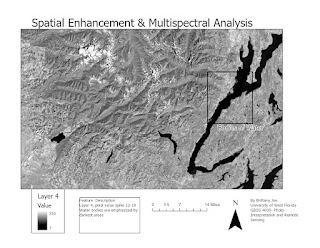
Spatial Enhancement & Multispectral Analysis

Image
In the lab, we learned how to apply spatial enhancements, perform a multispectral analysis, and create band indices. We also observe significant differences and improvements to imagery.  Used a grayscale symbology to analyze pixel values spikes between 12-18. Bodies of water are represented by the darkest shade (black). Explored a focal statistic with a 3x3 kernel to see what changed. Lines are much sharper and in areas in the image where urban areas are present the buildings seemed to be outlined in lighter shades. This kind of imaging can be replicated simply using RGB values of 5, 4, 3, and pixel values between 12-18 in band 4 within ERDAS Imagine. Within True color imagery, urban areas and snow is represented by white and/or pale coloring. Then exploring if the same coloration will apply for another display of band colors. Despite having high pixel values within bands 1-4 and bands 5 and 7 are with the lower values. RGB values 1, 3, and 4 highlight snow and urban areas' similar...

Exploration to ERDAS Imagine and Integrating into Mapping

Image
 Objective:  Recognize and understand functions of ERDAS Imagine Recognize differences to four types resolutions Interpret and analyze thematic raster in ERDAS Imagine Description     To prevent potential program crashes in ArcGIS Pro, we can use ERDAS Imagine to create and make adjustment to the map so that the data can be transferred smoothly. 

Land Classification and Ground Truthing

Image
 Summary Utilize observation skills to create a land use/ land classification map of Pascagoula, MS aerial map. Classified land use according to the USGS Standard Land Use/ Land Cover Classification System (LULC)  through Level I/ II codes and descriptions. Took random sample points through the map and apply "ground truth" to these locations and investigate the accuracy of my LULC classifications. 

Photo Interpretation and Remote Sensing Lab 1: Visual Interpretation

Image
 Identifying Features in Aerial Photographs Lab objectives  Understand gradient levels of tone and texture present in aerial photos.  Deduct and identify attributes in photos based on hints provided in shadows, shapes, and other factors.  Recognize differences in true color imaging and false-color infrared imaging