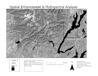
Spatial Enhancement & Multispectral Analysis
In the lab, we learned how to apply spatial enhancements, perform a multispectral analysis, and create band indices. We also observe significant differences and improvements to imagery.
Used a grayscale symbology to analyze pixel values spikes between 12-18. Bodies of water are represented by the darkest shade (black). Explored a focal statistic with a 3x3 kernel to see what changed. Lines are much sharper and in areas in the image where urban areas are present the buildings seemed to be outlined in lighter shades. This kind of imaging can be replicated simply using RGB values of 5, 4, 3, and pixel values between 12-18 in band 4 within ERDAS Imagine.Within True color imagery, urban areas and snow is represented by white and/or pale coloring. Then exploring if the same coloration will apply for another display of band colors. Despite having high pixel values within bands 1-4 and bands 5 and 7 are with the lower values. RGB values 1, 3, and 4 highlight snow and urban areas' similarity with true-color imagery. Within the histogram changing the brightness of the colors doesn’t affect the clarity of the images. Used LandSat 4 ™ - 6 Bands sensor type with true color common band combination.
False-color image. RGB values 3,4 and 5 displays snow as a very bright blue/ purple color. Readjust the histogram values so that the snow is presented with the brightest display. Also with the neon color stand out in contrast to the surrounding background so finding this combination was very nice to work with. Set Sensor type to Landsat 4 ™ - 6 Bands and Common Band Combination to False Color.


Comments
Post a Comment